For class this week, we were told that we have an upcoming project that is siting a fictional wind turbine on Mt. Tom in Holyoke, Massachusetts, and seeing how visible it would be to the surrounding towns. Before any GIS work can be done, though, a flowchart must be created. This will help keep us organized along the way with our project and help keep us from pounding our heads on the keyboard in frustration or saying "um...now what do I do????" Flowcharts make you think about the process before you even touch the mouse so that you won't get stuck..hopefully. So below is the flowchart that I have created for this upcoming project. Keep in mind that this is what is called a "living document." I will be making changes to the flowchart as I go along in the project as we do not know the specifics of the project, so different criteria will be specified or different tools will be used. This is just the very basic flowchart that I will be using.
Wind Turbine on Mt. Tom
Hope you enjoy it and stay posted to see the project and final flowchart!
Tuesday, October 29, 2013
Tuesday, October 22, 2013
Solar Wind Farm
1) The site had to have a slope angle of 20 degrees or less
2) The slope of the site had to have a southerly aspect (135 to 225 degrees)
3) The wind speed at 30m had to be above 5 m per second.
The towns that I did my analysis on were Adams and Peru, both in Massachusetts.
Below is the map of the two towns side by side showing the suitable parcels.

Or see below
View Larger Map
Below is a quick map of the suitable parcels of Adams, Massachusetts.
You can also click here to download the KMZ file for Adams, Massachusetts, and open it with Google Earth.
Below is a quick map of the suitable parcels of Peru, Massachusetts
You can also click here to download the KMZ file for Peru, Massachusetts, and open it with Google Earth.
Enjoy!
Friday, October 11, 2013
New England Proximity Clause - Westfield State University
Good Friday morning! For our class assignment this week, we had to determine which cities in Connecticut would be eligible for the New England Proximity Clause for Westfield State University. Under this clause, students who are closer to Westfield State University are eligible to pay almost the same rate for tuition as in-state residents pay, which is a huge break on tuition costs. The map below shows which cities are eligible for the tuition break due to their proximity to Westfield State.

The map below is the map that would be sent to the Bursars office (The Office of the Bursar is responsible for billing of student tuition accounts.) It is not quite as pretty but it is an example of what the Bursars office would look for in a map since they do not need any background basemap, they simply need to know which cities are eligible and which are not.

Enjoy and stay posted for more soon!


Enjoy and stay posted for more soon!
Easthampton Parcels
For the same class assignment as the Westfield Parcels, we had to pick another city out of 6 possible cities and conduct the same analysis on the city. Same criteria as for the Westfield parcels; at least 10 acres in size, at least 100 feet away from any wetlands area, and already commercial or industrial zoned. Below is the map of the one parcel that I found that was suitable in Easthampton for the fictional BioTech industrial park.
 To see the report that I wrote for this analysis, please click here.
Hope you enjoy it and stay posted for more soon!!
Hope you enjoy it and stay posted for more soon!!
Westfield Parcels
For class this week, we were asked to figure out how many suitable parcels in Westfield there would be for a fictional BioTech industry given certain criteria: the parcel had to be at least 10 acres in size, at least 100 feet away from any wetland, and it had to already be commercial or industrial zoned. Below is the map of the suitable parcels that I found for this project given these criteria.
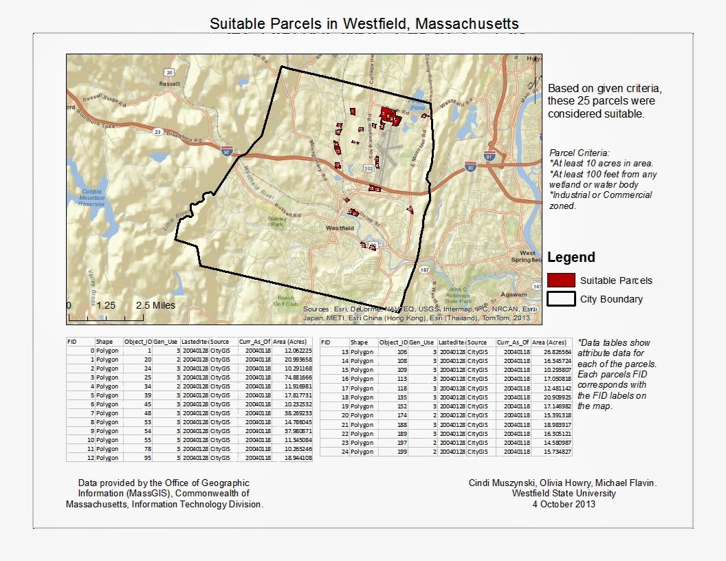 To see the report that I wrote for this analysis, please click here.
Hope you enjoy it!
Hope you enjoy it!
Monday, October 7, 2013
13 Western Massachusetts Cities
Good Monday morning everyone! For our last assignment, we were asked to make a poster comparing the demographics (housing, race, gender, etc) of 13 Western Massachusetts cities. Below is the poster I created for this assignment.

Hope you find it informative! Stay posted for more soon!

Subscribe to:
Comments (Atom)